So the work I presented at the crit was a summation of work since the hand in of the Briefing Document (which I happened to get 69% in...).


Drawing of multiple frames of reference in St Albans, Hand-drawing and collage, Pencil on Watercolour paper, Ali Abbas 2009

 Map showing largest Roman cities in Roman Britian and proximity from London. London at the centre, then St Albans, Silchester, Canterbury, Cirencester, Wroxeter
 Map showing Verulamium overlaid onto contemporary St Albans


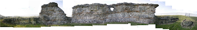 Photostitch of Roman wall ruins on east of Verulamium park. Ali Abbas 2009

Drawing showing image Copyright St Albans Museum and overlayed section through ground, charts showing rainfall and annual temperatures. The drawing illustrates the numerous factors that enabled the markings over the fields of Roman roads appearing during the summer of 1976. Pencil & Photocopied images on Watercolour paper. Ali Abbas 2009

Photo looking East of the St Albans skyline. The Cathedral can be seen to the right of the image. Ali Abbas 2009

As a development of building an astrolabe, I created Astrolabe MKII. This was a heath robinson-esque device that reiterates the spatial qualities of the Astrolabe in its attempt to coordinate sidereal time and coordinated universal time (UDC) through the projection of one system onto another.
Photo of mechanical clock mechanism, Ali Abbas 2008
Using a standard mechanical clock mechanism, the device progresses over time as a clock would. By winding the mechanism, the series of gears revolve at the rate of seconds, minutes, hours, days and years.
This system is connected to a revolved set of discs containing simple switches that represent sunrise and sunset. An arm rotates around each disc (a separate disc for each day of the year) over the course of a day. It is connected to the minutes gear, so any movement is directly related to UDC time. As the arm passes the sunset switch, the circuit is complete until it reaches the sunrise switch and a light is activated. The duration of the lit period changes over the course of the year as the length of day becomes shorter or longer.
Drawing of Astrolabe MKII, Pencil drawing, Ali Abbas 2009
The automatic sign produced by the Astrolabe MKII in coordination with the daily celestial cycle eliminates the prerequisite in the Astrolabe to possess knowledge of how the device works, and how to make sense of the overlaid scales. Comprehending the relationship between UDC and sidereal time is effectively democratised. I wasn't actually too happy with the outcome, the drawing was quite nice but I sort of felt like I was creating objects for the sake of creating objects, as opposed to developing the spatial qualities of my work.
Drawing of multiple frames of reference in St Albans, Hand-drawing and collage, Pencil on Watercolour paper, Ali Abbas 2009
So to reinvigourate my project, I decided to use the spatial structure of the Astrolabe (dealing with place, time, culture, celestial spheres, projection, transposing of various scales and means of understanding the world) as a tool for comprehending my site. I created a drawing that exposed the various frames of reference on the site and how they relate to one another.
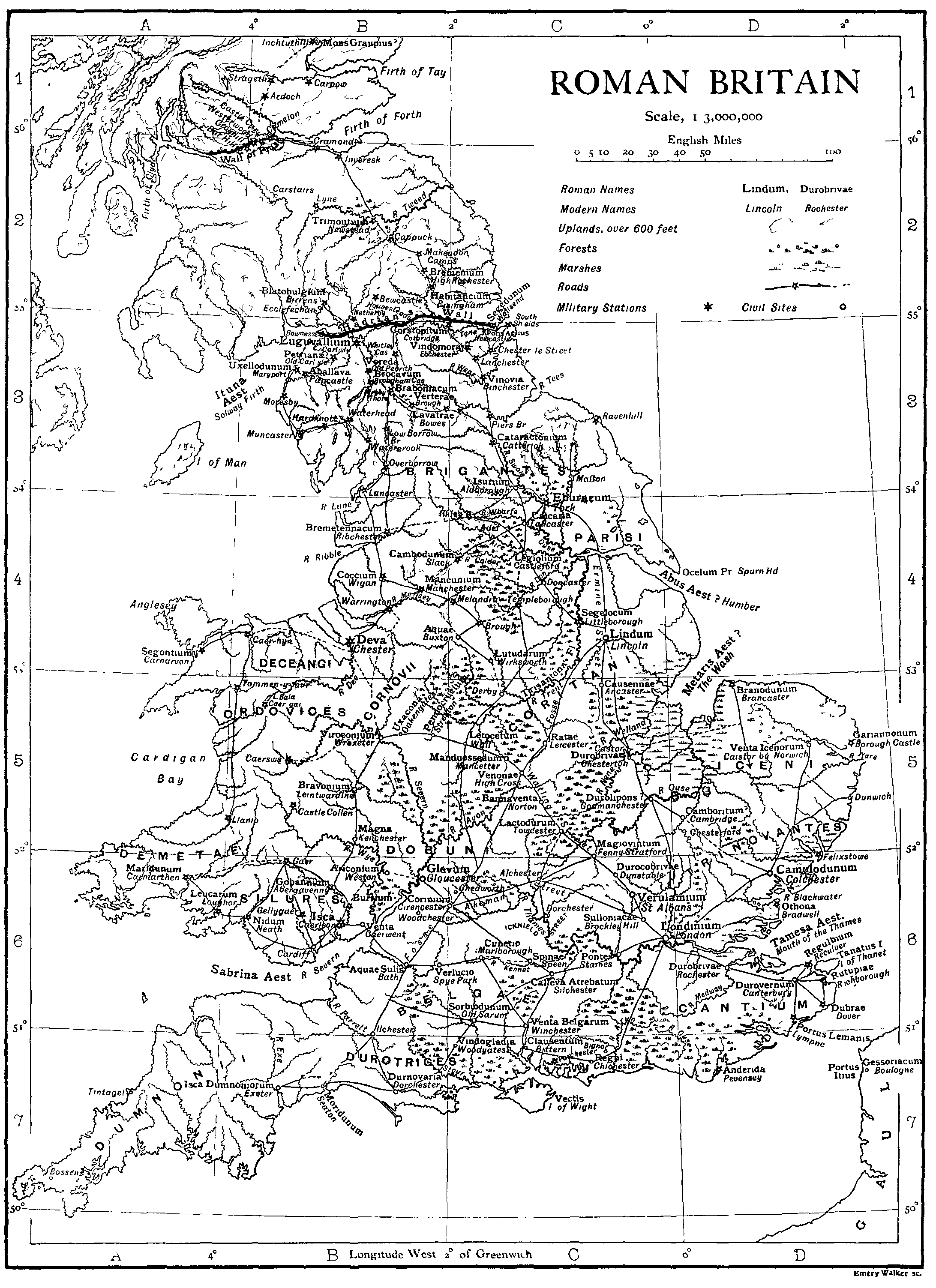
Map showing Verulamium in relation to the Roman Empire
Map showing largest Roman cities in Roman Britian and proximity from London. London at the centre, then St Albans, Silchester, Canterbury, Cirencester, Wroxeter Beneath contemporary St Albans verulamium park lies the ancient city of Verulamium, the 3rd largest city in Britain during the Roman Empire. The gates located on the surrounding city walls led to Chester, Silchester and London. Within the walls, the urban grain of Verulamium was a typically Roman orthogonal grid, only disrupted on the south side by Watling Street. This angle was believed to be due to a pre-existing Celt settlement.
Map showing Verulamium overlaid onto contemporary St Albansgoogle earth image
When drawing the site, I feel like it almost is a contemporary astrolabe...with my architectural intervention becoming the means of reading the astrolabe and finding sense between how the various scales interact with one another.
Below are a series of panoramas created to show the landscape I'm dealing with:
Below are a series of panoramas created to show the landscape I'm dealing with:
View looking South of Verulamium park including Lake and Roman wall ruins, Ali Abbas 2009
View looking North West of Verulamium Park, Ali Abbas 2009
View looking West of Verulamium park, including Roman Wall ruins, Ali Abbas 2009
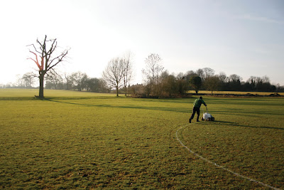
View looking West of the London Gate of Roman Verulamium and football pitches, Ali Abbas 2009
View looking North of Roman wall ruins
View of side of MUF Architects' Hypocaust Building and Gabion wall landscaping. Looking East. Ali Abbas 2009
Internal image of the Hypocaust building by MUF Architects. The architecture frames the relics; the mirrored ceiling provides glimpses of the outside and inside, and carefully placed openings naturally light parts of the ruins without overexposure. Lovely, modest intervention. I need to make this part of my precedents study. Ali Abbas 2009
The contemporary site of Verulamium contains only fragments of the past, much is undiscovered and hidden beneath the earth. Parts of the wall and London gates have been excavated; the theatre and hypocaust are also exposed. The present landuse is mostly recreational parkland. Part is seasonally occupied by school football fields, and to the north the Verulamium museum exists over the site of the Forum. Coincidentally while I was surveying the site, groundsmen were marking in chalk the position of the football fields. Like they were scarring the landscape with new orientational territories. It creates further interplay between the contemporary and historical Verulamium. The football pitches frame the relics.
Photostitch of Roman wall ruins on east of Verulamium park. Ali Abbas 2009 Groundsman marking out football lines on the Verulamium turf with chalk. Ali Abbas 2009
Aside from these uncovered relics, one can only imagine the extent of the city through the growth of trees beside the line of the Roman wall on the east and North Verulamium perimeter.
Aside from these uncovered relics, one can only imagine the extent of the city through the growth of trees beside the line of the Roman wall on the east and North Verulamium perimeter.
Several astronomical phenomena have been particularly inspiring over the past fortnight. The first was an image from Verulamium, The Roman City of St Albans by Rosalind Niblett. Taken during the drought of 1976, the simultaneous record high temperatures and low rainfall led to exceedingly thin soils and the positions of the subterranean roman remains appearing as markings on the fields. Alignment of historical, celestial, geological strata...
Drawing showing image Copyright St Albans Museum and overlayed section through ground, charts showing rainfall and annual temperatures. The drawing illustrates the numerous factors that enabled the markings over the fields of Roman roads appearing during the summer of 1976. Pencil & Photocopied images on Watercolour paper. Ali Abbas 2009
The second was my own experience while studying the site. Standing on the north west side of the site (middle of a field looking eastwards towards the Hypocaust building), with the sun overhead at 2pm (Thursday, 29th January) a ray of light shone towards the St Albans skyline and reflected from a passing train directly towards me. The alignment of the train network (an artificial timing system based on the current cultural routines) and the ever present daily solar location and fluctuating weather conditions seems both coincidental and a phenomenon that occurs only once a year at that particular place and time. For the rest of the year, one can observe the various frames of reference my themselves.
Photo looking East of the St Albans skyline. The Cathedral can be seen to the right of the image. Ali Abbas 2009
Sketch showing the coincidental alignment of Sun, train and human position in the Verulamium landscape. Pencil on Watercolour paper. Ali Abbas 2009
The opportunity to see these aligned reminds me of a passage from Cyber_Reader by Neil Spiller. In Erik Davis_Techgnosis: Magic, Memory and the Angels of Information_1993 he quotes a passage from the Divine Invasion by Phillip K. Dick (Mr. Blade Runner) which says:
'The total structure of Scripture formed, then, a three-dimensional cosmos that could be viewed from any angle and its contents read. According to the tilt of the axis of observation, different messages could be extracted...If you learned how, you could gradually tilt the temporal axis, th axis of true depth, until successive layers were superimposed and a vertical message-a new message-could be read out..' Dick, P. K., 'Man, Android and Machine', in Science Fiction at Large, Peter Nicholls (ed), New York, Harper & Row, 1976, p216
This suggests an opportunity for an architecture that can evoke similar spatial qualities. It can uncover hidden messages, images and memories in the landscape that exist between the various fields of orientation. One can decode (recode) the landscape depending upon how one interacts with the architecture.
This is about as far as my review went. Comments from my crit in the next post...
