3 days to go
6000 words so far. About 1/2 way through. Oh help me lord.
In the library. It's 10pm. This should be more depressing.
Sunday, March 15, 2009
Monday, March 09, 2009
Post crit thoughts
Once again, it's been a mighty long time since my last post...mainly due to work picking up and it being just over a week until our 10,000 word deadline and today's crit.

 Sketches showing potential ice collection/ice house/underground ice chamber, Ali Abbas 2009
 Environment Agency Flood Map, St Albans
 Walter Pichler drawing, from Flickr, Michael.Flarion
 Walter Pichler drawing, from Flickr, Michael.Flarion
So where am I now? It feels like the project changes every week. Perhaps this is because I was scared to propose something definite, so without committing on paper to something the project could be anything.
The architecture links the daily activities of the park, enabled and enhanced by new interventions, and a heightened awareness of one's place in space and time. A series of mundane architectural typologies are juxtaposed with the re-emerging subterranean city. Each architecture is located at particular nodes relating to the underground remains. As one engages with the architecture, they can better comprehend their position in space and time. Phenomenological parkitectures.
Overall massing programme, Verulamium Park, Ali Abbas 2009
These architectures are as follows:
- Icecream van - manifesting as an icecream parlour. This shall sit above the Verulamium Inn, burnt down and rebuilt three times during the previous life of the town. Sitting on a junction of 5 streets, the inn was in a prominent location for travellers coming into the city from London. In addition to its institutional watering hole status, the inn housed a number of social enterprises aimed at regulars including the making and selling of clothes brooches. Perhaps the presence of such a number of craftworks lead to the buildings collapse on each occasion. This architecture shall question the role of the icecream vendor as an orientational device, and how the spatial qualities evoked by the icecream van enable the park dweller to better comprehend their space and time.
Sketches showing potential ice collection/ice house/underground ice chamber, Ali Abbas 2009 - Changing rooms - a building linking the temple of Cybele beneath the earth with the ritual of sport. Involving the collection changing into sporting attire, the reorientation from daily life to that of the sportman, and back again. Also some link to the archaeological votive pits.
- Boathouse/Flood defences - situated above the old city walls and the limits of the flood plane. How does this architecture function in times when the lake isn't flooded, and what higher purpose can the architecture satisfy? Perhaps for boating, or as a refuge for wildfowl? This one really needs developing.
Environment Agency Flood Map, St AlbansThe actual comments by Tony Swannel and Graham Farmer from the crit were as follows:
How does one folly relate to another?
Why is it called a Boathouse? Must it fulfil this function?
Simplify each architecture, take all of them and how they relate to one another. Look at how they reveal a meaning about place.
A charm in how they use the everyday building to uncover a meaning in a place.
John Haydock's Mask Projects
A risk that I'll do too much in each project. 'Less is more'
Simple placement, modest. 'Fairy shelter'
Simplify - simple theme applied to each e.g. threshold
Parc La Vilette
The masterplan becomes the narrative - use this drawing as the narrative
The work of Walter Pichler
Walter Pichler drawing, from Flickr, Michael.FlarionWalter Pichler drawing, from Flickr, Michael.FlarionDraw the architecture as settings, and draw spatially as experiences.
Sverre Fehn's glacier museum.
Sverre Fehn's Glacier Museum, Norsk Bremuseum Fjærland, Flickr, user: ChannelBeta.Net
Monday, February 23, 2009
Yellow Brick Road?
So I haven't posted in almost a week now. Over the past few days I've been working hard attempting to make sense of what this architecture does, and how the elements in it can enable a series of motions, traces and arbitrary activities to occur.
A big inspiration was reading Re-Working Eisenman by Peter Eisenman, particularly the essay End of the Classical. He discusses a proposal for a new 'timeless' architecture, devoid of representation of meaning through images and the assignment of objects to represent ideas. The architecture would have no predetermined origin or end. Starting points would arise from arbitrary moments created by the functioning of the architectural process. He discusses the architecture as a text; one which enables many undetermined actions to come from it. The traces that come from these actions allow the architecture to be read as an enabler or indicator. How one decodes the architecture is no longer important.
I interpret this text with regards to contemporary orientation as a commentary on changing modes of orientation - from a realm of A Priori knowledge - where signs in the city signify particular ways of reading the city. They are unpoetic and assume the city dweller to be acting in the city a prior, i..e they are only interested in satisfying functional needs. Eisenman's proposal could be interpreted as an arbitrary means of orientation. It involves exploration and the unfolding of the landscape to all possibilities. It doesn't assume anything. It removes meaning from all architectures, and redeploys meaning as one created by all individuals through their own explorations. One person's Eiffel Tower is another person's Parc La Villette.
So what does this all mean? Well perhaps I should read the way my architecture will function in a similar way. I create a series of pieces across the landscape of Verulamium, all of whom enable people experiencing the space to comprehend the overlaying of various means of orientation over the course of time. Some of the architectures will only remain open for short periods of time. This could create a tension between the user's time and the presence and absence of time as monuments interact with the celestial passage of time, and then passively interact after their motions have subsided. Each architecture would operate specifically to its location within the landscape, and interact with other architectures at specific times to uncover histories of the site momentarily (for instance the appearance of roman ruins as crop marks).
More to come. Back to the drawing board.
Tuesday, February 17, 2009
Mary-Ann Ray's Hospital and Archaeological Repository for Tiber Island
 Image from http://www.studioworksarchitects.com/projects/projects.htm
Mary-Ann Ray
Mary-Ann Ray's Hospital and Archaeological Repositry for Tiber Island interestingly deals with the contemporary and historical Rome. The project makes a clear distinction between the surface, and the volume 'below'. The surface deck as a text for the future, and the beneath as a reference to the historical, manifesting as an archaeological repository. The island becomes an ark, with the repository orientated across the 'boat' like structural ribs "recalling and 'building in' the memory of the ancient island that took the form of a ship of stone".
In this project, the River Tiber orientates the building towards the flow of water, and as a bridge between one side of the river and the other. It places the static typology beneath the surface, like a depositing in the soil or reburial of retrieved objects. The exposed hospital mirrors the transient surface conditions between land and water, and either sides of the river. Healing patients are the traces of an enabling architecture, one that accomodates individual experiences and treatments that arbitrarily occur as patients enter the building.
Saturday, February 14, 2009
Proper Project Orientation.

The image by photographer Bill MacEwan is inspiring in the way he disorientates the viewer in his image Proper Project Orientation. The network of connected stairways, platforms, wires, pipes suggest multiple ways of viewing the image, is it a plan, a section or an upside down image? The materiality and colours are also very appealing. The contrast of light and dark gives some hint to the perspective from which the 'architecture' is being viewed.
Friday, February 13, 2009
Briefing Document Conclusions
The following are conclusions and questions I made in the briefing document, perhaps they'll jog my memory for future proposals.
• Exploration of a new mode of orientation within the contemporary historical city that transcends the digital and analogue. Th e new architecture should attempt to encourage the healing of a schizophrenic urban environment that orientates the digitally literate and the analogue city user.
• Can the proposed architecture create a physical interface between our physical and virtual orientation devices?
• Can a new architecture re-engage the digital city (the virtual space disassociated with the physical realm) with the historical city of memory?
• Exploration of the evolution of the cultural image in a historic city (the city of memory), and the role that historical fragments can play in contemporary orientation. A new physical orientation device should attempt to re-engage historical fragments with new layers of urban identity and the virtual city. It should encourage the interaction between the digital and existing physical communities.
• Exploration of an analogue/digital hybrid architecture that can uncover new identities related to our inherent connection to a means of orientating oneself in time and space.
• Through the design vehicle of a contemporary clock tower, examine how the epistemology of this typology can be redefi ned in the contemporary city. As a new orientational typology, how can the territory of this architecture embrace or reconstitute existing urban territories.
• How can a new clock tower architecture transcend the schism between the disoriented and oriented city dweller. Th e architecture must engage with the community in a manner than encourages a reconceptualization of an individual’s personal layers of orientation. This may engage the disoriented person (a marginalised individual through loss of personal identity, or negative bandwidth) with means for finding one’s identity, or engaging the digital user with the analogue city as a means of giving meaning and substance to their exploits in the physical world.
• Question the notion of orientation by proposing an architecture that does not orient through the imposing of a particular ideology or way of seeing the world. Rather, it enables the pursuit of many different ways of seeing our position in space and time.
• The architecture must question the origins of our cultural images and how these encourage a particular approach to orientation. Can many diff erent cultural images coexist and enable the pursuit of one’s own means of living amongst the diversity of others. Can the new architecture enable diversity and personal identity while promoting the notion of community?
The New Verulamium
This evening I've spent mostly reading theoretical architectural texts, namely extracts from Neil Spiller: Vacillating Objects; Manuel De Landa: Policing the Spectrum; Paul Virilio: The Aesthetics of Disappearance; Margaret Wertheim: The Pearly Gates of Cyberspace.
While several proposed interesting ideas about the influence of the virtual domain upon the physical domain, I still feel my work lacks depth. It feels like I'm yet to scrape the surface of what I'm really dealing with architecturally. My understanding of the site was enhanced by a recent visit to St Albans and attempting to draw spatially how I understand the landscape from numerous frames of reference. Perhaps this is the key. The ability for the image to be comprehended in a multitude of ways from a variety of perspectives, both physically and metaphysically. Wertheim cites the Memory Theatre by Giulio Camillo and the Apple desktop working in similar ways, but enabling the processing of complex ideas into simple structured 'spaces' associated with memorable images or motifs.
Image courtesy of: http://www.spamula.net/blog/i05/camillo.gif
From a glance, the theatre displays reminders of numerous ideas associated collectively with their location spatially and virtually through their alignment to a particular planet. It enables complex subjects to be memorised and arranged for future consultation, in a structure akin to the ordering of the world wide web or contemporary filing systems.
Maybe this ordering of memories and images reflects how we navigate through familiar landscapes. It becomes our means of orientation, through place and through our own thoughts. We assign images fused into our heads that are attributed to greater memories. Some of these remain in the subconscious realm of our psyche, until triggered by similar images encountered throughout our daily lives. The strength of the image ingrained in our minds will determine the degree to which past experiences are recalled. Could we create environments that can orientate one in the future by creating powerful images in the present? Perhaps this isn't the direction my project will take, but a thought nonetheless.
So how can the project progress in the physical? I.e. stop writing and start creating and drawing. The relationship between St Albans and Verulamium is interested. The Roman city is abandoned. The exposed relics become sites that represent the trauma of citizens as the city fell and the paganist traditions were dismantled.

Photo of the Verulamium walls (South) and the London Gate, Ali Abbas 2009
Extraordinarily, the town relocates as one ideological system supersedes another. Should settlements be nomadic? What becomes of decadent components of an old city? In the case of St Albans, they represent an old culture. One that for 400 years outlawed alien beliefs, so much so that Alban was martyred for practising Christianity. Verulamium seems forgotten, hidden beneath layers of history. Small parts are uncovered and framed by iron railings. These frames become the only reference points for inquiry into the past. One navigates between them, and they project onto the landscape reference points for the hidden city. Why was the city never redeployed as a second settlement, or as a new built function. The contemporary use of the site as a park, described as the 'lungs of the city', becomes a vital place for people to escape the stresses of the city. Escaping contemporary St Albans and effectively arriving back in Verulamium. The new Verulamium...
While several proposed interesting ideas about the influence of the virtual domain upon the physical domain, I still feel my work lacks depth. It feels like I'm yet to scrape the surface of what I'm really dealing with architecturally. My understanding of the site was enhanced by a recent visit to St Albans and attempting to draw spatially how I understand the landscape from numerous frames of reference. Perhaps this is the key. The ability for the image to be comprehended in a multitude of ways from a variety of perspectives, both physically and metaphysically. Wertheim cites the Memory Theatre by Giulio Camillo and the Apple desktop working in similar ways, but enabling the processing of complex ideas into simple structured 'spaces' associated with memorable images or motifs.
Image courtesy of: http://www.spamula.net/blog/i05/camillo.gif
From a glance, the theatre displays reminders of numerous ideas associated collectively with their location spatially and virtually through their alignment to a particular planet. It enables complex subjects to be memorised and arranged for future consultation, in a structure akin to the ordering of the world wide web or contemporary filing systems.
Maybe this ordering of memories and images reflects how we navigate through familiar landscapes. It becomes our means of orientation, through place and through our own thoughts. We assign images fused into our heads that are attributed to greater memories. Some of these remain in the subconscious realm of our psyche, until triggered by similar images encountered throughout our daily lives. The strength of the image ingrained in our minds will determine the degree to which past experiences are recalled. Could we create environments that can orientate one in the future by creating powerful images in the present? Perhaps this isn't the direction my project will take, but a thought nonetheless.
So how can the project progress in the physical? I.e. stop writing and start creating and drawing. The relationship between St Albans and Verulamium is interested. The Roman city is abandoned. The exposed relics become sites that represent the trauma of citizens as the city fell and the paganist traditions were dismantled.
Photo of the Verulamium walls (South) and the London Gate, Ali Abbas 2009
Extraordinarily, the town relocates as one ideological system supersedes another. Should settlements be nomadic? What becomes of decadent components of an old city? In the case of St Albans, they represent an old culture. One that for 400 years outlawed alien beliefs, so much so that Alban was martyred for practising Christianity. Verulamium seems forgotten, hidden beneath layers of history. Small parts are uncovered and framed by iron railings. These frames become the only reference points for inquiry into the past. One navigates between them, and they project onto the landscape reference points for the hidden city. Why was the city never redeployed as a second settlement, or as a new built function. The contemporary use of the site as a park, described as the 'lungs of the city', becomes a vital place for people to escape the stresses of the city. Escaping contemporary St Albans and effectively arriving back in Verulamium. The new Verulamium...
Wednesday, February 11, 2009
Crit Comments
The following were comments from my crit (09-02-2009) made by Michael Stacey and David Short:
The project has some interesting starting points but should be built up from layers of information,as opposed to just built upon one moment (the alignment of train and celestial spheres).
Questioning what my architecture is commenting on? Be 'hard nosed' (?)
What is the context of the project? Perhaps imagine the project is about the decoding of knowledge and information existing on various levels around the site, and making it accessible.
Draw more drawings (!?) and use themto explore the idea.
Access a deeper territory.
Think about the technology and materials I might use in the architecture. It doesn't have to arrive at the latter stages of the project.
If I were to do an exercise exploring the location of Roman settlements in relation to the contemporary city, would it uncover a special urban condition in St Albans, where the position of the settlement has moved over time. I wonder how useful doing an exercise would really be though? I guess it's another way of understanding the uniqueness of the site, but past that it might be another Red Herring to put in the fishtank. The movement of the settlement is based on the burial site of St Alban, and a change from following the invading Romans to following Christianity, which Alban was martyred for.
The relinking of people to the landscape and environment, on simple terms through the seasons, but perhaps in a more sophisticated a deeper level? Think about this
Some things to look at were:
Longitude by Dava Sobel - The thorniest scientific problem of the 18th century was how to determine longitude. Many thousands of lives had been lost at sea over the centuries due to the inability to determine an east-west position. This is the engrossing story of the clockmaker, John "Longitude" Harrison, who solved the problem that Newton and Galileo had failed to conquer, yet claimed only half the promised rich reward.
http://tinyurl.com/cuj9rj
Peter Rice's Moonlight Amphitheatre
So that's all they said. It was fair, I showed where I am but they wanted some proposals as to how I build on my ideas. I think I have a clear understanding of elements of the site. What I need to develop over the coming weeks is my architectural approach to the site, and how this can enhance my study into orientation.
Tuesday, February 10, 2009
Crit Presentation
So the work I presented at the crit was a summation of work since the hand in of the Briefing Document (which I happened to get 69% in...).


Drawing of multiple frames of reference in St Albans, Hand-drawing and collage, Pencil on Watercolour paper, Ali Abbas 2009

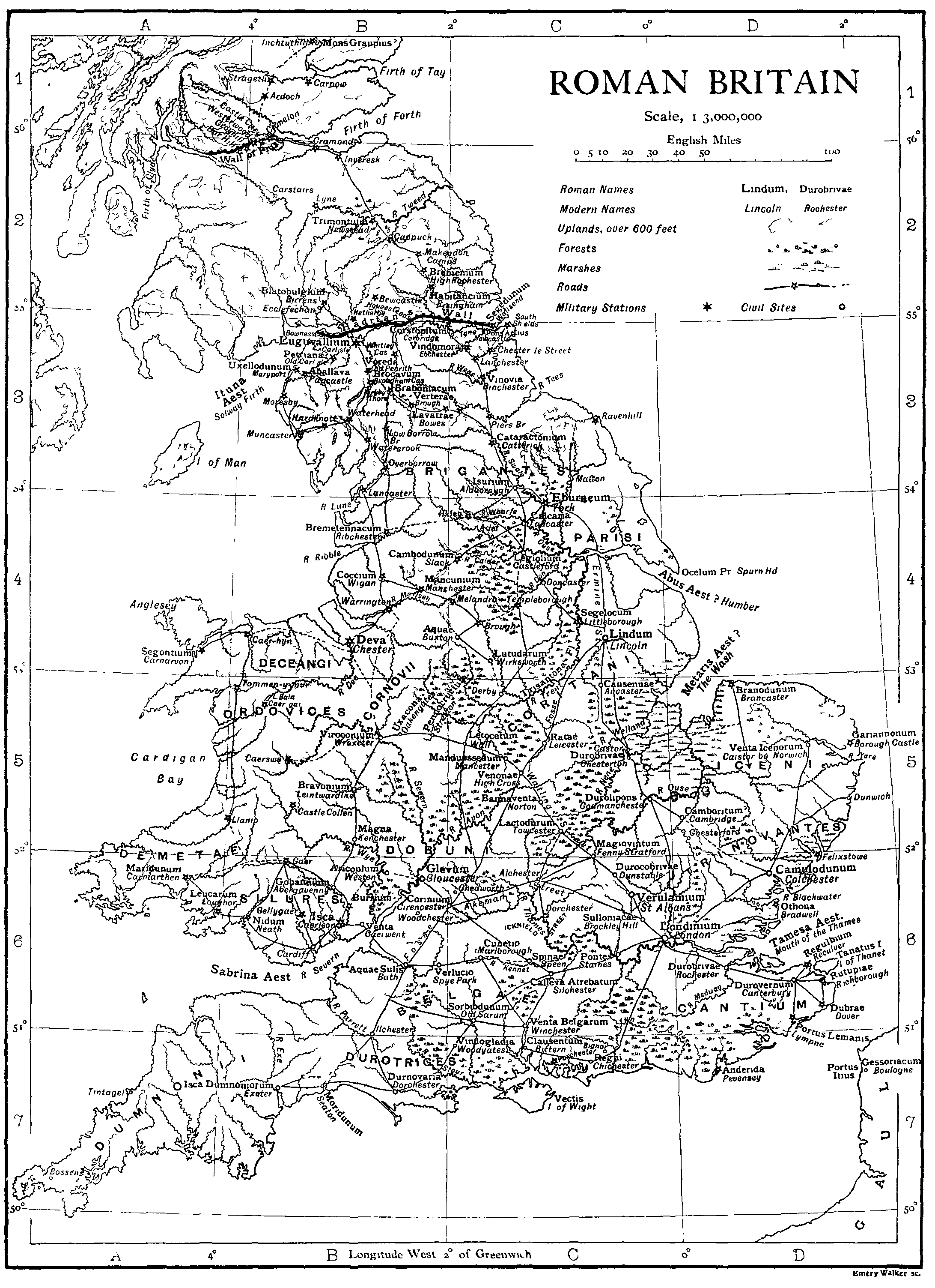
 Map showing largest Roman cities in Roman Britian and proximity from London. London at the centre, then St Albans, Silchester, Canterbury, Cirencester, Wroxeter
 Map showing Verulamium overlaid onto contemporary St Albans


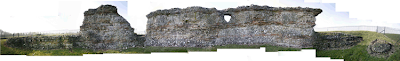 Photostitch of Roman wall ruins on east of Verulamium park. Ali Abbas 2009

Drawing showing image Copyright St Albans Museum and overlayed section through ground, charts showing rainfall and annual temperatures. The drawing illustrates the numerous factors that enabled the markings over the fields of Roman roads appearing during the summer of 1976. Pencil & Photocopied images on Watercolour paper. Ali Abbas 2009

Photo looking East of the St Albans skyline. The Cathedral can be seen to the right of the image. Ali Abbas 2009

As a development of building an astrolabe, I created Astrolabe MKII. This was a heath robinson-esque device that reiterates the spatial qualities of the Astrolabe in its attempt to coordinate sidereal time and coordinated universal time (UDC) through the projection of one system onto another.
Photo of mechanical clock mechanism, Ali Abbas 2008
Using a standard mechanical clock mechanism, the device progresses over time as a clock would. By winding the mechanism, the series of gears revolve at the rate of seconds, minutes, hours, days and years.
This system is connected to a revolved set of discs containing simple switches that represent sunrise and sunset. An arm rotates around each disc (a separate disc for each day of the year) over the course of a day. It is connected to the minutes gear, so any movement is directly related to UDC time. As the arm passes the sunset switch, the circuit is complete until it reaches the sunrise switch and a light is activated. The duration of the lit period changes over the course of the year as the length of day becomes shorter or longer.
Drawing of Astrolabe MKII, Pencil drawing, Ali Abbas 2009
The automatic sign produced by the Astrolabe MKII in coordination with the daily celestial cycle eliminates the prerequisite in the Astrolabe to possess knowledge of how the device works, and how to make sense of the overlaid scales. Comprehending the relationship between UDC and sidereal time is effectively democratised. I wasn't actually too happy with the outcome, the drawing was quite nice but I sort of felt like I was creating objects for the sake of creating objects, as opposed to developing the spatial qualities of my work.
Drawing of multiple frames of reference in St Albans, Hand-drawing and collage, Pencil on Watercolour paper, Ali Abbas 2009
So to reinvigourate my project, I decided to use the spatial structure of the Astrolabe (dealing with place, time, culture, celestial spheres, projection, transposing of various scales and means of understanding the world) as a tool for comprehending my site. I created a drawing that exposed the various frames of reference on the site and how they relate to one another.
Map showing Verulamium in relation to the Roman Empire
Map showing largest Roman cities in Roman Britian and proximity from London. London at the centre, then St Albans, Silchester, Canterbury, Cirencester, Wroxeter Beneath contemporary St Albans verulamium park lies the ancient city of Verulamium, the 3rd largest city in Britain during the Roman Empire. The gates located on the surrounding city walls led to Chester, Silchester and London. Within the walls, the urban grain of Verulamium was a typically Roman orthogonal grid, only disrupted on the south side by Watling Street. This angle was believed to be due to a pre-existing Celt settlement.
Map showing Verulamium overlaid onto contemporary St Albansgoogle earth image
When drawing the site, I feel like it almost is a contemporary astrolabe...with my architectural intervention becoming the means of reading the astrolabe and finding sense between how the various scales interact with one another.
Below are a series of panoramas created to show the landscape I'm dealing with:
Below are a series of panoramas created to show the landscape I'm dealing with:
View looking South of Verulamium park including Lake and Roman wall ruins, Ali Abbas 2009
View looking North West of Verulamium Park, Ali Abbas 2009
View looking West of Verulamium park, including Roman Wall ruins, Ali Abbas 2009
View looking West of the London Gate of Roman Verulamium and football pitches, Ali Abbas 2009
View looking North of Roman wall ruins
View of side of MUF Architects' Hypocaust Building and Gabion wall landscaping. Looking East. Ali Abbas 2009
Internal image of the Hypocaust building by MUF Architects. The architecture frames the relics; the mirrored ceiling provides glimpses of the outside and inside, and carefully placed openings naturally light parts of the ruins without overexposure. Lovely, modest intervention. I need to make this part of my precedents study. Ali Abbas 2009
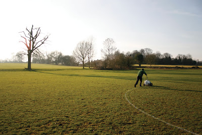
The contemporary site of Verulamium contains only fragments of the past, much is undiscovered and hidden beneath the earth. Parts of the wall and London gates have been excavated; the theatre and hypocaust are also exposed. The present landuse is mostly recreational parkland. Part is seasonally occupied by school football fields, and to the north the Verulamium museum exists over the site of the Forum. Coincidentally while I was surveying the site, groundsmen were marking in chalk the position of the football fields. Like they were scarring the landscape with new orientational territories. It creates further interplay between the contemporary and historical Verulamium. The football pitches frame the relics.
Photostitch of Roman wall ruins on east of Verulamium park. Ali Abbas 2009 Groundsman marking out football lines on the Verulamium turf with chalk. Ali Abbas 2009
Aside from these uncovered relics, one can only imagine the extent of the city through the growth of trees beside the line of the Roman wall on the east and North Verulamium perimeter.
Aside from these uncovered relics, one can only imagine the extent of the city through the growth of trees beside the line of the Roman wall on the east and North Verulamium perimeter.
Several astronomical phenomena have been particularly inspiring over the past fortnight. The first was an image from Verulamium, The Roman City of St Albans by Rosalind Niblett. Taken during the drought of 1976, the simultaneous record high temperatures and low rainfall led to exceedingly thin soils and the positions of the subterranean roman remains appearing as markings on the fields. Alignment of historical, celestial, geological strata...
Drawing showing image Copyright St Albans Museum and overlayed section through ground, charts showing rainfall and annual temperatures. The drawing illustrates the numerous factors that enabled the markings over the fields of Roman roads appearing during the summer of 1976. Pencil & Photocopied images on Watercolour paper. Ali Abbas 2009
The second was my own experience while studying the site. Standing on the north west side of the site (middle of a field looking eastwards towards the Hypocaust building), with the sun overhead at 2pm (Thursday, 29th January) a ray of light shone towards the St Albans skyline and reflected from a passing train directly towards me. The alignment of the train network (an artificial timing system based on the current cultural routines) and the ever present daily solar location and fluctuating weather conditions seems both coincidental and a phenomenon that occurs only once a year at that particular place and time. For the rest of the year, one can observe the various frames of reference my themselves.
Photo looking East of the St Albans skyline. The Cathedral can be seen to the right of the image. Ali Abbas 2009
Sketch showing the coincidental alignment of Sun, train and human position in the Verulamium landscape. Pencil on Watercolour paper. Ali Abbas 2009
The opportunity to see these aligned reminds me of a passage from Cyber_Reader by Neil Spiller. In Erik Davis_Techgnosis: Magic, Memory and the Angels of Information_1993 he quotes a passage from the Divine Invasion by Phillip K. Dick (Mr. Blade Runner) which says:
'The total structure of Scripture formed, then, a three-dimensional cosmos that could be viewed from any angle and its contents read. According to the tilt of the axis of observation, different messages could be extracted...If you learned how, you could gradually tilt the temporal axis, th axis of true depth, until successive layers were superimposed and a vertical message-a new message-could be read out..' Dick, P. K., 'Man, Android and Machine', in Science Fiction at Large, Peter Nicholls (ed), New York, Harper & Row, 1976, p216
This suggests an opportunity for an architecture that can evoke similar spatial qualities. It can uncover hidden messages, images and memories in the landscape that exist between the various fields of orientation. One can decode (recode) the landscape depending upon how one interacts with the architecture.
This is about as far as my review went. Comments from my crit in the next post...
Crit February 9th 2009
Yesterday I had an interim review with Michael Stacey and David Short. It was an opportunity to talk about my project from the start to tutors who hadn't seen it before, hence a fairly good exercise to sure up in my mind what exactly my project deals with.
I'll introduce it from the start, for those who don't know what I've been looking at.
As a starting point, the study examines how the perception of our position in the world is shaped by our relationship to surroundings, people, ideas and our possessions. Our alignment to these things creates what we call our identity and this gradually shifts as we sift through what we do know, what don’t know, and what we choose not to know or to neglect. In part, I specifically address how the artist and scientist respectively make sense of the universe and attempt to relay their positions through various metaphorical and real devices; specifically through the Panorama and Diorama buildings.

Cross section and plan through Robert Baker's panorama, Leicester Square, London, 1976 in Oettermann, S., 1997, The Panorama, New York, Zone Books, pg 104
This developed into examining the historical preoccupation with locating ourselves within the universe. The study concentrates on the era prior to the machine; specifically the transition from the geometric and geocentric theory of the world as narrated by Aristotle to that of the Astrolabe in the dawning Islamic World. By introducing movement to geometry through the Astrolabe, the Islamic astronomers suggested an early form of relativity, where all points in the sky were relative to one another and the earth below. Through this device, medieval society cultivated an intimate understanding of the earth and sky, and the way in which both were interlinked in the present and as a means for predicting the future.
 Unequal hours diagram show shorter hours during the winter, longer hours in the winter

Diagram show construction of Astrolabe geometry using stereographic projection
I consider the implications of using the celestial spheres as a universal instrument for negating how we live our lives, translated architecturally through the clock tower. As our cultural images change, our means of orientating ourselves within the landscape alter. Parts of the landscape are reappropriated and assigned with different meanings. During medieval times in St Albans, the abbey and clock tower became a focal reference point from which time (based on that kept by the monks) was relayed to the populus.
Map showing global internet bandwidth
http://throb.typepad.com/photos/uncategorized/world_bandwidth_usage.jpg
Can the overlaying of historical and contemporary orientational fields reveal the true nature of our position in the world in space and time, and a new clock tower architecture? How does a contemporary 'clock tower' manifest?
I'll introduce it from the start, for those who don't know what I've been looking at.
As a starting point, the study examines how the perception of our position in the world is shaped by our relationship to surroundings, people, ideas and our possessions. Our alignment to these things creates what we call our identity and this gradually shifts as we sift through what we do know, what don’t know, and what we choose not to know or to neglect. In part, I specifically address how the artist and scientist respectively make sense of the universe and attempt to relay their positions through various metaphorical and real devices; specifically through the Panorama and Diorama buildings.
Cross section and plan through Robert Baker's panorama, Leicester Square, London, 1976 in Oettermann, S., 1997, The Panorama, New York, Zone Books, pg 104
This developed into examining the historical preoccupation with locating ourselves within the universe. The study concentrates on the era prior to the machine; specifically the transition from the geometric and geocentric theory of the world as narrated by Aristotle to that of the Astrolabe in the dawning Islamic World. By introducing movement to geometry through the Astrolabe, the Islamic astronomers suggested an early form of relativity, where all points in the sky were relative to one another and the earth below. Through this device, medieval society cultivated an intimate understanding of the earth and sky, and the way in which both were interlinked in the present and as a means for predicting the future.
Unequal hours diagram show shorter hours during the winter, longer hours in the winterDiagram show construction of Astrolabe geometry using stereographic projection
I consider the implications of using the celestial spheres as a universal instrument for negating how we live our lives, translated architecturally through the clock tower. As our cultural images change, our means of orientating ourselves within the landscape alter. Parts of the landscape are reappropriated and assigned with different meanings. During medieval times in St Albans, the abbey and clock tower became a focal reference point from which time (based on that kept by the monks) was relayed to the populus.
 Wallingford Clock, St Albans
In a contemporary society where time is democratised through personal time keeping devices, the clock tower becomes an orientation device in a geographical manner (like Kevin Lynch's image of the city notion), and new means of orientation relate to our global positioning and information networks. Mobile phone masts and wireless connectivity enable us to orientate to our own networks, and the strenght of these signals and their interface's determine the degree to which we become connected.
Map showing global internet bandwidth
http://throb.typepad.com/photos/uncategorized/world_bandwidth_usage.jpg
Can the overlaying of historical and contemporary orientational fields reveal the true nature of our position in the world in space and time, and a new clock tower architecture? How does a contemporary 'clock tower' manifest?
Welcome to A Landscape for the Disoriented
Hello and welcome to my blog 'A Landscape for the Disoriented'. I've created this mainly for the purpose of keeping track of my progress through my 6th year architecture thesis, particularly for the special emphasis study. Over the coming months I'll add my sketches, drawings, articles, readings, and random musings related to my thesis.
Subscribe to:
Comments (Atom)
